Saint Lucia Air and Sea Ports Authority Cruise
Official ports authority source for Castries harbour and passenger-port context.


Cruise planning
Use the timetable to see upcoming cruise ship calls, busy-day signals, ship counts, and port context alongside the guide, map, weather, and readiness tools.
Schedule note
Port schedules can change because of weather, berth availability, itinerary updates, and operational decisions. Verify important times with your cruise line or the port authority before travel.
Country, code, and on-shore essentials.
Saint Lucia
LCCAS
14.010, -60.987
Hotel search loads here when you reach this section.
VoyagePro may earn a commission if you book through Expedia, at no extra cost to you.

Castries cruise berths are close to the town and harbour area, with taxis used for beaches and island tours.
Before going ashore, confirm the berth or tender point, local time, all-aboard deadline, and the meeting location for any independently booked transport or tour.
Usually docks
Walkable
Independent visits are practical for town and with arranged transport for island plans.
This port works best when you confirm the exact arrival point, choose one coherent plan, and protect the return to the ship with a comfortable time buffer.
Best for
Needs extra planning when
This section draws on information from Saint Lucia Air and Sea Ports Authority Cruise and Saint Lucia Tourism Authority.
Confirm the actual berth first—local access can change substantially between terminals.
Castries calls can use Pointe Seraphine on the north side of the harbor or La Place Carenage beside the city center. Confirm the berth because the two arrivals have different walking routes.
La Place Carenage opens directly into central Castries. From Pointe Seraphine, allow roughly 15–25 minutes to walk around the harbor, or use a short taxi or water-taxi service when available; beaches and island sights require road transport.
Cruise-line tours and beach transfers vary by sailing.
Taxi and tour transfer are practical for beaches, viewpoints, and longer island drives.
This section draws on information from Saint Lucia Air and Sea Ports Authority Cruise and Saint Lucia Tourism Authority.
A concise summary of useful details found in port, municipal, transport, terminal, and tourism material.
Saint Lucia Air and Sea Ports Authority Cruise
Official ports authority source for Castries harbour and passenger-port context.
Saint Lucia Tourism Authority
Official tourism source for Saint Lucia visitor planning.
This section draws on information from Saint Lucia Air and Sea Ports Authority Cruise and Saint Lucia Tourism Authority.
Start with the usable time you have ashore, then leave a comfortable return margin.
Quick call
Keep the day close to the port and choose one or two reliable nearby stops.
Half day
Castries, beaches, viewpoints, markets, and Pitons-area excursions are common planning points. La Place Carenage opens directly into central Castries. From Pointe Seraphine, allow roughly 15–25 minutes to walk around the harbor, or use a short taxi or water-taxi service when available; beaches and island sights require road transport.
Long call
Castries, beaches, viewpoints, markets, and Pitons-area excursions are common planning points. Keep the ship's all-aboard time as a hard deadline and allow extra time for weather, traffic, queues, security, or tender operations.
This section draws on information from Saint Lucia Air and Sea Ports Authority Cruise and Saint Lucia Tourism Authority.
Hilly island roads and longer excursions can affect mobility and timing.
This section draws on information from Saint Lucia Air and Sea Ports Authority Cruise and Saint Lucia Tourism Authority.
Keep the ship's all-aboard time as a hard deadline and allow extra time for weather, traffic, queues, security, or tender operations.
This section draws on information from Saint Lucia Air and Sea Ports Authority Cruise and Saint Lucia Tourism Authority.
These answers use the reviewed operational fields above; check the linked source when a detail affects a booking or transfer.
Castries calls can use Pointe Seraphine on the north side of the harbor or La Place Carenage beside the city center. Confirm the berth because the two arrivals have different walking routes.
La Place Carenage opens directly into central Castries. From Pointe Seraphine, allow roughly 15–25 minutes to walk around the harbor, or use a short taxi or water-taxi service when available; beaches and island sights require road transport.
Cruise-line tours and beach transfers vary by sailing. Taxi and tour transfer are practical for beaches, viewpoints, and longer island drives.
Independent visits are practical for town and with arranged transport for island plans.
This section draws on information from Saint Lucia Air and Sea Ports Authority Cruise and Saint Lucia Tourism Authority.
Guide review and sources
Operational details can change by berth, weather, and ship call. Confirm important arrangements before travel.
Choose a few places that fit your time ashore, then check access and transport before setting out.
La Place Carenage opens directly into central Castries. From Pointe Seraphine, allow roughly 15–25 minutes to walk around the harbor, or use a short taxi or water-taxi service when available; beaches and island sights require road transport.
Arrival location reference
Nature and park
A mapped nature and park to consider for a port day in Castries.
A mapped nature and park to consider for a port day in Castries. Check current access, opening hours, admission requirements, and reservations before setting out.
This is near the destination reference, but the practical walking route still depends on the assigned berth or tender landing.
Near the destination reference; confirm the walking route
Coastal landmark
A mapped coastal landmark to consider for a port day in Castries.
A mapped coastal landmark to consider for a port day in Castries. Check current access, opening hours, admission requirements, and reservations before setting out.
Plan local transport from the assigned terminal or landing rather than assuming this stop is walkable.
Local transport may be needed from the arrival point

Local landmark
A source-backed option to consider for a port day in Castries.
A source-backed option to consider for a port day in Castries. Check current access, opening hours, admission requirements, and reservations before setting out.
This is near the destination reference, but the practical walking route still depends on the assigned berth or tender landing.
Near the destination reference; confirm the walking route
Scenic landmark
A source-backed option to consider for a port day in Castries.
A source-backed option to consider for a port day in Castries. Check current access, opening hours, admission requirements, and reservations before setting out.
Use the official visitor information for directions. No sufficiently reliable geotagged match was found, so this place is intentionally not pinned.
Reviewed 2026-07-25. Location placement, transport, and attraction information retain separate sources so each can be checked and updated independently.
Choose an upcoming call and ship to turn the published schedule into a practical planning window.
Choose a call date
Choose your ship

Your selected call
Arrival
8:00am
Departure
6:00pm
Scheduled window
10h
Planning return buffer
Count back from the published departure time.
Planning checkpoint: 4:30pm
This is a personal planning checkpoint, not the ship's official all-aboard time. Always follow the time and instructions issued onboard.
Guide match for this window
A longer outing may fit, but protect the return journey from weather, traffic, queues, and tender delays.
Dates, ships, and times come from the currently published cruise-call records. Schedules can change, and passenger totals represent available ship-capacity data rather than a forecast of people going ashore.
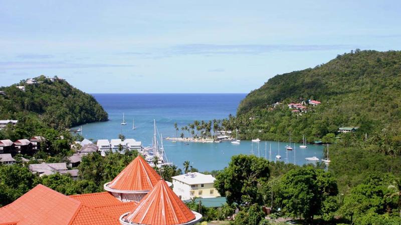
The typical image of a lush tropical paradise comes to life on the friendly island of St Lucia. Despite its small size – just 27 miles long and 14 miles wide – St Lucia is rich in natural splendour with dense emerald rainforest, banana plantations and orchards of coconut, mango and papaya trees. The twin peaks of Les Pitons, now a UNESCO World Heritage Site rise dramatically 2,000 feet into the sky and dominate the island. Look out for unusual birds with brilliant plumage such as the St Lucia parrot, see a surprising diversity of exotic flora and enjoy the warm hospitality of the islanders in the small villages and open-air markets.
Please be aware that St Lucia is a small, mountainous island, with steep, winding and bumpy roads. Customers with back and neck problems should take this into consideration when booking an excursion.
Keep exploring
 eSIM for travellers
Use a GigSky travel eSIM for maps, messaging, and travel updates ashore. Choose a plan that covers the countries you will visit.
Land plans do not include at-sea coverage. Check destination coverage and phone compatibility before buying.
VoyagePro may earn a commission if you buy through this link, at no extra cost to you.
Explore tour options for your port day. Check the meeting point and return time against your ship’s schedule before booking.
Excursion partner

Independent shore excursions
Select any tour card to view current details, availability, and booking on the Shore Excursions Group website.

Remember Tarzan? Think about all the fun he had zipping around through trees! This zip line excursion gives you the adrenaline he probably felt, but in a much safer way.

Discover a breathtaking view of the rainforest aboard an open-air gondola. Beautiful fauna and flora, panoramic views, and photo opportunities await.

Glide along the Roseau River, one of St. Lucia's largest and longest waterways, on a bamboo raft and experience nature on this unique adventure.
VoyagePro may earn a commission if you book through these links, at no extra cost to you.
Destination photography: Nick Fewings, Artem Pochepetsky.
Place photos are resized for display and cropped where needed.


